Navigating new urban cycle infrastructure can be confusing, leading to hesitation and risk. The key to safety isn’t just memorising rules, but understanding the ‘predictive logic’ behind the design. This guide decodes the language of Low Traffic Neighbourhoods, CYCLOPS junctions, and segregated lanes, transforming you from a reactive rider into a proactive navigator who can anticipate conflicts and move with confidence through the city.
The sudden appearance of new road layouts, from segregated superhighways to planters blocking residential streets, has left many urban cyclists feeling both grateful and confused. You want to use this new infrastructure, but the unfamiliar rules and designs can be intimidating. The common advice to “wear high-vis” or “be aware” feels inadequate when faced with a multi-lane, roundabout-style cycle junction or a bus stop that seems to float in the middle of your lane. These generic tips fail to address the core problem: you’re trying to apply old knowledge to a completely new system.
But what if the secret to safely navigating this new landscape wasn’t just about being more cautious, but about being more intelligent? What if the infrastructure itself was speaking a language you could learn to understand? The real key to safety lies in decoding the design intent behind each new layout. By understanding *why* a junction is shaped a certain way or *why* a street is closed to through-traffic, you can shift from simply reacting to your surroundings to proactively navigating them.
This guide moves beyond the basics. We will explore the predictive logic built into modern cycling infrastructure. We’ll break down the priority rules at the most advanced junctions, show you how to interact safely with pedestrians in re-designed spaces, and equip you with the knowledge to choose the best route for your skill and stress level. It’s time to turn confusion into confidence and reclaim your city streets.
To help you master this new urban environment, this article breaks down the most common and confusing elements of modern cycle infrastructure. Each section provides clear, practical advice based on the design principles of these new systems.
Summary: LTNs and Superhighways: How to Use New Cycle Infrastructure Safely?
- Priority Rules: Who Goes First on the New Cyclops Junctions?
- Pedestrians and Passengers: How to Navigate Bus Stop Bypasses Without Conflict?
- One Way Streets: Identifying Legal Contraflows vs. Illegal Riding
- Low Traffic Neighbourhoods: Why They Are Good for Cyclists Despite the Controversy?
- Fill That Hole: How to Report Dangerous Infrastructure effectively to the Council?
- Quiet Streets vs. Cycle Superhighways: Choosing the Stress-Free Route to Work
- Heatmaps: How to Use Crowd-Sourced Data to Avoid Dangerous Roads?
- Eye Contact and Positioning: How to Predict Driver Behaviour Before It Happens?
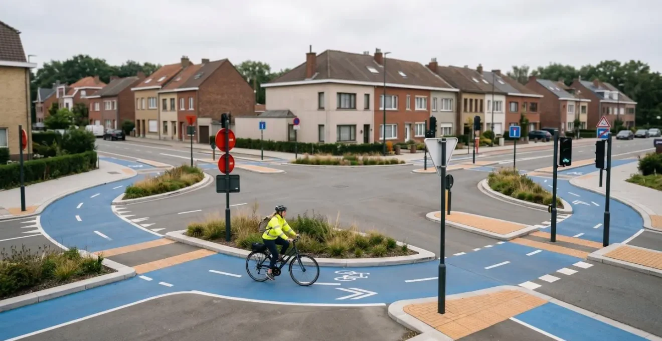
Priority Rules: Who Goes First on the New Cyclops Junctions?
The CYCLOPS (Cycle Optimised Protected Signals) junction can appear chaotic, but its design follows a simple, powerful logic: separating conflicts. Instead of cyclists, pedestrians, and cars all competing for space at the same time, the system gives cyclists and pedestrians a dedicated, fully protected signal phase where all motor traffic is held at a red light. This is the core principle to remember: when your light is green, you have clear priority over motor vehicles within the junction’s circulatory track.
The design features a roundabout-style cycle track around the junction’s perimeter. As a cyclist, you follow this track. This design allows you to make right turns in a single, fluid movement, rather than having to wait in the middle of a busy junction. Manchester’s implementation provides a clear model: the system gives cyclists and pedestrians a simultaneous green light, allowing them to cross while all cars wait. This fundamental design, as detailed in Manchester’s CYCLOPS junction protocol, dramatically reduces the risk of collisions with motor vehicles.
While you have priority over traffic, you must still be aware of pedestrians. The design includes zebra crossings over the cycle track. Here, the standard rule applies: give way to pedestrians who are crossing or waiting to cross. Your mindset should be to maintain a safe, controlled speed through the junction, allowing you to stop easily if needed. By understanding that the design separates you from cars but integrates you with pedestrians, you can navigate these junctions with confidence.
Pedestrians and Passengers: How to Navigate Bus Stop Bypasses Without Conflict?
The “bus stop bypass,” also known as a “floating bus stop,” is designed with one goal in mind: to allow cyclists to continue their journey without having to pull out into general traffic behind a stopped bus. The cycle lane continues uninterrupted behind the bus shelter, while passengers get on and off from an “island” platform. This is a huge safety improvement, but it creates a new, predictable point of conflict: pedestrians crossing the cycle lane to get from the bus to the main pavement.
Your primary responsibility here is speed management and awareness. As you approach a bus stop bypass, you must anticipate that people will be crossing. Look ahead to see if a bus is present or approaching. If passengers are alighting, they may be focused on getting to the pavement and not looking for cyclists. They have priority, often indicated by zebra markings across the cycle lane. Even without markings, you should be prepared to slow down or stop.
A good practice is to gently use your bell as you approach an occupied bus stop to signal your presence. This isn’t an aggressive “get out of the way” signal, but a polite “hello, I’m here.” Listen for the audio cues of the bus, such as the “doors opening” chime, which signals that passengers are about to step out. The design intends to keep you moving, but not at the expense of pedestrian safety. By treating the area between the bus stop island and the pavement as a dedicated pedestrian crossing zone, you use the infrastructure exactly as it was intended.
One Way Streets: Identifying Legal Contraflows vs. Illegal Riding
Cycling the “wrong way” down a one-way street is a common source of conflict and confusion. However, there is a clear distinction between riding illegally and using a legal “contraflow” lane designed specifically for cyclists. Understanding the visual language of the infrastructure is key to telling them apart and asserting your right of way correctly.
A legal contraflow lane is always clearly marked. Look for two key signs:
- A blue circular sign showing a bicycle, sometimes with the text “Contraflow”.
- At the “No Entry” sign (red circle with a white horizontal bar) at the start of the one-way street, there will be a supplementary plate underneath that reads “Except cycles”.
If you see these signs, you are legally permitted to cycle against the flow of motor traffic, usually in a dedicated, marked lane. If these signs are not present, you are riding illegally.
This is part of a wider shift in road priority. Recent updates to the Highway Code have established a new “Hierarchy of Road Users,” placing more responsibility on drivers of larger vehicles to look out for more vulnerable users like cyclists. This is especially relevant at junctions, where cyclists now have priority when going straight ahead. This change is designed to prevent “left-hook” collisions where a turning vehicle cuts across a cyclist’s path. By understanding these new priorities, according to Cycling UK’s Highway Code guidance, you can position yourself more confidently and assertively, knowing the rules are designed to protect your journey.
Low Traffic Neighbourhoods: Why They Are Good for Cyclists Despite the Controversy?
Low Traffic Neighbourhoods (LTNs) have become a focal point of controversy, often portrayed as causing traffic chaos on boundary roads. However, for cyclists, the data paints a very different picture. The design intent of an LTN is simple: to remove “rat-running” through-traffic from residential areas using modal filters like bollards or planters. This creates quieter, safer streets that prioritise walking and cycling for local journeys.
The benefits are not just theoretical; they are backed by extensive data. A 2024 review of the Waltham Forest LTN programme in London provides a compelling argument for their effectiveness.
Case Study: Waltham Forest LTN Health and Economic Benefits
A longitudinal review of the Waltham Forest scheme found it generated over £1 billion in health economic benefits for a cost of just £100 million—a 10:1 return on investment. The study also documented an 18% decrease in total street crime and a significant 56-61% reduction in traffic volumes within the LTN zones. Crucially, this was achieved with minimal impact on boundary roads, debunking one of the main criticisms.
Beyond the economic and safety figures, the impact on active travel is profound. Research on London’s schemes shows clear behavioural changes, with studies from the London Cycling Campaign revealing people in Waltham Forest’s LTNs do on average 1-2 hours more walking and 15-20 minutes more cycling per week. For cyclists, LTNs are more than just a route; they are a network of safe, low-stress corridors that make cycling a genuinely viable and pleasant option for everyday trips. They represent a fundamental shift in urban planning, reclaiming residential streets for people rather than cars.
Fill That Hole: How to Report Dangerous Infrastructure effectively to the Council?
Even the best-designed cycle routes can be rendered dangerous by a single, unrepaired pothole. Surface defects are a major risk for cyclists, capable of causing serious injury and damage to bikes. While it can feel like a thankless task, reporting these hazards is not only a civic duty but also a legal necessity for councils, who can only be held liable for defects they know about. The scale of the problem is immense; in 2024, Freedom of Information data revealed that a single authority, Durham County Council, received over 66,000 pothole reports.
To make your report effective and ensure it leads to action, you need to provide clear, precise, and actionable information. A vague complaint is easily dismissed, but a well-documented report creates a legal record and makes it easy for a repair crew to locate and assess the problem. Using a centralised reporting tool like Fill That Hole streamlines the process, but the quality of your submission is what truly matters.
Your Action Plan: Reporting Potholes Effectively
- Pinpoint the Location: Use a GPS-based app or website like Fill That Hole (fillthathole.org.uk) to get precise coordinates. If reporting manually, provide a street address plus a specific landmark (e.g., “opposite house number 24, next to the large oak tree”).
- Document with Photos: Take at least three photos: a wide shot to show the context of the road, a close-up to show the pothole’s details, and a crucial photo with a common object (like a coin or a drinks can) placed inside or next to it to provide a sense of scale and depth.
- Report Immediately: Don’t wait. Reporting a defect as soon as you find it creates a time-stamped record. Councils have a legal defence if they are unaware of a hazard; your report removes that defence.
- Describe the Hazard: Briefly describe why it’s dangerous for cyclists. Is it on a corner? Hidden in a shadow? On a designated cycle lane? This adds urgency.
- Follow Up: Note the council’s target time for repairs (often available on their website). If the deadline passes without action, follow up on your report, referencing the original report number.
By following these steps, you transform from a frustrated victim of poor infrastructure into an effective agent of change, helping to make the roads safer for everyone.
Quiet Streets vs. Cycle Superhighways: Choosing the Stress-Free Route to Work
Not all cycle routes are created equal, and modern urban planning acknowledges this by offering two distinct types of networks: high-capacity Cycle Superhighways and low-traffic Quietways. Understanding the design philosophy behind each allows you to choose the route that best fits your needs, confidence level, and desired experience on any given day. This “two-speed” approach was a core part of London’s cycling vision.
We will offer two clear kinds of branded route: high capacity Superhighways, mostly on main roads, for fast commuters, and slightly slower but still direct Quietways on pleasant, low-traffic side streets for those wanting a more relaxed journey.
– Mayor of London, The Mayor’s Vision for Cycling in London (2013)
Cycle Superhighways are the arteries of the cycle network. They are designed for directness and speed, often running along main roads with fully segregated lanes. They are ideal for confident commuters who want to get from A to B as efficiently as possible. The infrastructure is robust, with clear signage and signalised junctions, but it means riding alongside heavy traffic.
Quietways, in contrast, are the capillaries. They prioritise comfort and pleasantness over outright speed. These routes guide you through parks, side streets, and Low Traffic Neighbourhoods, avoiding major roads wherever possible. They are perfect for less confident riders, families, or anyone simply wanting a more relaxed and enjoyable journey. While they may be slightly less direct, they offer a significantly lower-stress environment. Data from Transport for London shows that both types of routes are incredibly successful, with analysis showing a near-identical 54% increase in cycling on the East-West Superhighway and a 56% increase on Quietway 1, proving there is huge demand for both fast and relaxed cycling.
Heatmaps: How to Use Crowd-Sourced Data to Avoid Dangerous Roads?
In the quest for the perfect route, crowd-sourced data has become a powerful tool. Apps like Strava and Komoot generate “heatmaps” that show the most frequently used roads and paths by other cyclists. At a glance, they reveal the city’s hidden cycling corridors and popular commuting routes. The logic seems simple: follow the heat to find the best places to ride. However, using this data effectively requires a crucial layer of critical thinking.
A bright line on a heatmap indicates popularity, not necessarily safety. A busy main road with no cycle lane might have a very strong heatmap simply because it’s the most direct route between two points. Relying solely on heatmaps can inadvertently guide you onto routes that are fast but stressful and potentially dangerous. The true power of heatmaps is unlocked when you use them as a discovery tool, not as a definitive guide.
The proactive approach is to use a heatmap to identify potential corridors, then cross-reference them with an infrastructure map (like OpenStreetMap or local council cycle maps) to see *what kind of infrastructure* is actually on that route. Is that popular road a fully segregated superhighway, or is it a busy A-road with nothing but a painted line? Research consistently shows that the type of infrastructure is the single biggest determinant of safety. The safest routes are those with physically protected bike lanes, which are proven to reduce injuries and crashes. Your goal is to find where the “heat” overlaps with high-quality, segregated infrastructure. That sweet spot is where you will find the best routes: popular, direct, and safe.
Key Takeaways
- Decode Design Intent: The safest way to use new infrastructure is to understand *why* it was built that way, from the conflict-separating design of CYCLOPS junctions to the traffic-calming goals of LTNs.
- Position Proactively, Not Reactively: Use assertive road positioning, like taking the primary position, as a predictive tool to manage your space and prevent dangerous situations before they occur.
- Use Data Critically: Leverage tools like heatmaps and reporting apps, but always with a critical eye. Cross-reference popular routes with infrastructure maps and provide detailed, actionable information when reporting defects.
Eye Contact and Positioning: How to Predict Driver Behaviour Before It Happens?
Of all the skills a city cyclist can develop, the most powerful is the ability to predict the actions of other road users. This isn’t a psychic power; it’s a skill built on a deep understanding of road positioning and non-verbal communication. While making eye contact with a driver is often cited as crucial, it can be unreliable. A driver might look at you but not truly “see” you. A far more effective strategy is to use your road position to make your intentions clear and your presence impossible to ignore.
The updated Highway Code empowers cyclists to use the lane more assertively for their own safety. The two key positions are:
- Primary Position (“Taking the Lane”): Riding in the centre of the lane. This should be your default position on quiet roads, in slower-moving traffic, and when approaching junctions or narrowings. It makes you more visible and prevents drivers from attempting a dangerous, close overtake.
- Secondary Position: Riding about 0.5-1.0 metre to the left of the moving traffic. This is appropriate when the road is wide enough for a vehicle to pass you safely (with at least 1.5m of space).
Taking the lane is not an aggressive act; it is predictive communication. By moving to the primary position well in advance of a junction, you are sending a clear signal that you are part of the traffic flow and intend to manoeuvre. This makes you a predictable and visible element that drivers must account for, rather than a surprise they might overlook at the last second. It is the ultimate expression of proactive navigation, allowing you to control your space and dictate how others interact with you, dramatically reducing the likelihood of conflict.
Now, take this knowledge with you on your next ride. Start by consciously identifying the design intent of one new piece of infrastructure, and practice using the primary position when it feels safe to do so. Transforming your mindset is the first step to mastering the urban landscape.