In summary:
- Success depends on ‘morale logistics’—proactively managing comfort, certainty, and fun—not just endurance.
- Plan your route based on the ‘surface bottleneck’: the least capable bike in your group dictates the terrain.
- Use strategic snack breaks and ‘adventure objectives’ like a café stop to maintain high spirits and energy.
- Adopt a flexible riding formation, with adults switching between leading for pace and following as the ‘Chief Morale Officer’.
- Choose the right navigation app (like Komoot) that prioritises family-friendly points of interest over performance metrics.
The idea of a 20-mile family bike ride is the stuff of core memories: a proper adventure, fresh air, and a shared sense of achievement. The reality, however, can often be a mix of dropped chains, flagging energy, and the dreaded tantrum that brings the whole expedition to a grinding halt. Many guides will tell you to « pack snacks » or « check your bikes, » but this advice barely scratches the surface of what makes or breaks a long family ride.
The secret isn’t just about pedalling further; it’s about mastering the art of ‘morale logistics’. This is the proactive management of the three primary causes of meltdowns: discomfort, uncertainty, and boredom. A successful family adventure isn’t a test of endurance, but a carefully planned operation where every decision, from tyre choice to the timing of a cake stop, is a strategic move to keep spirits high.
This guide moves beyond the obvious to give you the tactical framework we use at our charity to help families unlock bigger, happier adventures. We’ll explore how to audit your bikes for the terrain, the crucial difference between navigation tools, the art of fuelling small riders, and how to position yourselves on the path for maximum safety and morale. By focusing on preventing the problems before they start, you can turn that ambitious 20-mile goal into a joyful reality.
Summary: Your Strategic Guide to a Tantrum-Free Family Ride
- Gravel, Tarmac, or Mud: Is Your Hybrid Bike Ready for the Local Railway Path?
- OS Maps vs. Google: Why You Shouldn’t Trust Your Phone on Rural Greenways
- Cake Logistics: Timing Your Breaks to Keep Morale High on Family Rides
- Leading or Following: Where Should You Position Yourself When Riding with Kids?
- Bells and Politeness: How to Pass Walkers and Horses Without Conflict?
- No Signal in the Valleys: Why Offline Maps Are Essential for Welsh Adventures
- Beyond the Trail Centre: How to Find Legal Bridleways Worth Riding in the UK?
- Komoot vs. Strava Routes: Which Planner Finds the Best Quiet Lanes in the UK?
Gravel, Tarmac, or Mud: Is Your Hybrid Bike Ready for the Local Railway Path?
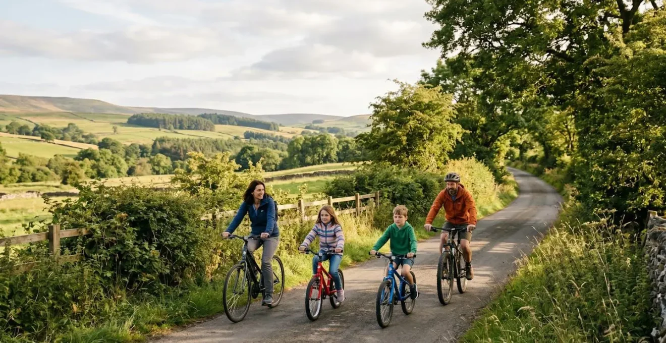
The first principle of morale logistics is eliminating physical discomfort. A 20-mile ride will expose any weakness in your equipment, and a problem that’s a minor annoyance at mile one can become a ride-ending disaster by mile 15. Before you even think about the route, you must consider the ‘surface bottleneck’—the single least capable bike in your group. A route with gravel sections is no fun if one child is on a bike with slick, narrow tyres designed for smooth tarmac.
Your route choice must be dictated by what every bike can comfortably handle. A parent’s rugged hybrid or mountain bike might be able to tackle anything, but if your youngest is on their first pedal bike, you are effectively a ‘smooth-tarmac-only’ group. Ignoring this leads to excessive effort, a higher risk of punctures, and the kind of frustration that fuels meltdowns. A pre-ride audit isn’t just about safety; it’s about ensuring the bikes themselves aren’t the source of the struggle.
Case Study: The Weakest Link Strategy
A practical approach highlights that the family’s ‘surface bottleneck’ is determined by the least capable bike in the group, not the most advanced. Parents should assess each bike’s capability—from a child’s first pedal bike to an adult MTB—and let that dictate the route’s surface choice to avoid mechanical issues and comfort problems over 20 miles. This simple assessment prevents a common planning failure where the route is chosen based on the parents’ capabilities, not the child’s.
Before every long ride, performing a quick but thorough check on every bike is non-negotiable. This simple routine ensures that small, fixable issues don’t escalate into major problems far from home. It builds confidence and reinforces a culture of safety and preparedness within the family.
Action Plan: Pre-Ride Bike Check for Family Cycling
- Tire Pressure: Ensure tires are fully inflated to the recommended PSI. Underinflated tires are significantly harder to pedal and are more prone to punctures.
- Brake Test: Squeeze both brake levers to check responsiveness. They should feel firm, not soft or spongy. Visually inspect the brake pads for wear.
- Chain and Gears: Check the chain is clean and lightly lubricated. Run through the gears (if applicable) to ensure they shift smoothly.
- Quick-Release & Bolts: Check that wheels are securely fastened and that handlebar and seat post bolts are tight. A loose component can be extremely dangerous.
- Saddle Height: Re-check the saddle height, especially for fast-growing children. For confidence on varied terrain, they should be able to comfortably touch the ground with the balls of their feet.
OS Maps vs. Google: Why You Shouldn’t Trust Your Phone on Rural Greenways
Uncertainty is a major source of anxiety for both parents and children. Getting lost, taking a wrong turn onto a busy road, or realising a path is a dead end can instantly sour an adventure. While the UK’s National Cycle Network is an incredible resource, with over 786 million trips recorded in 2017, its paths are not always as straightforward as a line on a digital map suggests. Relying solely on a tool like Google Maps can be a critical error.
Google Maps is optimised for drivers. It often fails to distinguish between a smooth, family-friendly greenway and a muddy, overgrown track that happens to be a public right of way. For traffic-free adventures, you need tools that understand the texture of the journey. This is where dedicated mapping services like Ordnance Survey (OS) Maps shine, as they show detailed topography, and crucially, differentiate between footpaths, bridleways, and byways—information that is vital for legal and safe cycling.
This paragraph introduces the concept of making navigation part of the adventure. To combat boredom and build engagement, give your child a role. A simplified, printed map of a section of the route can transform them from a passive passenger into an active navigator.
As you can see, turning navigation into a game is a powerful tool. Asking your child to spot the ‘next big bridge’ or ‘the funny-shaped tree’ on their map gives them a sense of purpose and ownership over the journey. It’s a simple but highly effective tactic in your ‘morale logistics’ toolkit, turning a potential point of stress into a source of fun and engagement.
Cake Logistics: Timing Your Breaks to Keep Morale High on Family Rides
On a long ride with children, morale is everything, and morale is fuelled by calories. The most common mistake families make is waiting too long for a break. By the time a child says « I’m hungry » or « I’m tired, » their energy reserves are already depleted, and a tantrum is often imminent. The key is to move from reactive breaks to proactive ‘fuelling stops’, just like a professional cycling team.
Forget the idea of one big lunch stop halfway through. Instead, implement a strategy of ‘little and often’. A small, easy-to-eat snack every 45-60 minutes prevents energy levels from ever hitting zero. This approach avoids the dreaded ‘sugar crash’ and keeps a steady supply of fuel going to tired muscles and brains. Furthermore, framing the main café stop not just as a break, but as the ‘Adventure Objective’ or ‘Base Camp’, gives the entire ride a clear purpose and a rewarding goal to strive for.
This strategy transforms food from a simple necessity into a powerful motivational tool. The anticipation of the « best hot chocolate at the canal café » can power little legs over the last few miles in a way that nothing else can. Here’s how to structure your fuelling strategy for maximum effect:
- Individual ‘Musette Bags’: Pack a small, separate bag of snacks for each child. This gives them ownership and easy access, preventing arguments over who gets what.
- Timed Distribution: Set a timer on your phone. Announce « Snack time! » every 45 minutes, whether they say they’re hungry or not. Make it a fun, routine part of the ride.
- Mix Your Fuels: Include a mix of quick-release energy (like fruit, jellies, or a small chocolate bar) and slow-release energy (like a flapjack, trail mix, or half a sandwich) to provide both an instant boost and sustained power.
- The 10-Minute Rule: At every stop, enforce a rule that everyone must be off their bike for at least 10 minutes. This allows for a mental reset, stretches different muscles, and provides time for exploration.
- Build Anticipation: Talk about the ‘Adventure Objective’ from the start. Discussing what cake everyone will choose at the café builds positive motivation throughout the first half of the ride.
Leading or Following: Where Should You Position Yourself When Riding with Kids?
The simple question of « who rides where? » has a surprisingly strategic answer. The traditional formation of one adult at the front and one at the back is a decent starting point, but it’s static and often inefficient. On a 20-mile ride, your formation needs to be dynamic, adapting to the terrain, the group’s energy levels, and the specific needs of the moment. The goal is to create a secure, encouraging, and communicative bubble.
A more effective method is the ‘Accordion Formation’, a flexible system where parental roles change. The front rider’s job is to be the ‘Pace Car’, setting a steady, manageable speed and scanning ahead for hazards. The adult at the back, however, has the most important job: they are the ‘Chief Morale Officer’ (CMO). From this position, you can observe everything: who is starting to struggle, who needs a word of encouragement, and whose pedalling is getting sloppy (a key sign of fatigue). The CMO is the first line of defence against a brewing meltdown.
Case Study: The Accordion Formation System
This dynamic positioning system is advocated by experts like The Bikeability Trust, an organisation that has trained millions. Instead of a fixed ‘one front, one back’ setup, parents alternate roles. One adult leads to set a safe pace on narrow sections. On wider, safer paths, a parent can ride alongside a child for conversation and encouragement. The parent at the back acts as the CMO, observing for signs of fatigue and offering encouragement. This flexible approach, taught to over 5 million children, keeps the group engaged and safe.
This system also involves periods of riding alongside your child on safe, wide paths for conversation, boosting morale directly. This training has a proven impact on safety and confidence. In fact, research shows that after training, there is a significant improvement in children’s cycling abilities. According to The Bikeability Trust, more than 90% of children demonstrate safer cycling habits after completing their courses. This underscores the value of not just riding, but riding with intention and skill.
Bells and Politeness: How to Pass Walkers and Horses Without Conflict?
Traffic-free paths are a shared space. A sudden encounter with walkers, dog-walkers, or horse riders on a narrow path can be a source of stress and conflict, undermining the relaxed atmosphere you’re trying to build. As a family cycling group, you are ambassadors for the sport, and a key part of ‘morale logistics’ is ensuring interactions with other path users are positive and stress-free.
The key is early, calm, and clear communication. A bell is an essential piece of equipment, but its use requires finesse. A frantic, last-second ring can startle people more than it helps. The goal is to alert, not to alarm. Imagine you are approaching a narrow bridge with pedestrians on it. The correct protocol is not to speed up and hope they hear you, but to slow right down, ready to stop if necessary.
Teach your children the three-step passing protocol:
- Scan and Slow: As soon as you see people or animals ahead, slow your pace significantly. This shows respect and gives you more time to react.
- Alert Politely: When you are still some distance away, give a single, friendly ring of your bell. Follow this up with a clear, calm voice: « Excuse me, cyclists coming through when you’re ready! » A friendly voice is far more effective than a bell alone.
- Pass Slowly and Say Thank You: Pass with plenty of space and at a walking pace. Acknowledge the other users with a « Thank you! » or a friendly nod as you go by. This reinforces the positive interaction and teaches children good trail manners.
When it comes to horses, the rule is to be even more cautious. Horses can be easily spooked by the silent, fast approach of a bicycle. Announce your presence vocally and from much further away. Be prepared to stop completely and wait for the rider to signal that it is safe for you to pass. This small act of courtesy prevents dangerous situations and maintains good relationships on the trail.
No Signal in the Valleys: Why Offline Maps Are Essential for Welsh Adventures
Your smartphone is a powerful navigation tool, but its biggest weakness is its reliance on a mobile signal and a finite battery. On a 20-mile ride through rural greenways, especially in areas with rolling hills or valleys like much of Wales, you cannot assume you will have a consistent signal. The moment you lose signal, your live map becomes a useless blank screen, and a primary source of ‘uncertainty’ is introduced. The battery drain from a phone constantly searching for a signal is also immense.
The professional solution is to use offline maps. Apps like Komoot, OS Maps, and Ride with GPS allow you to download a planned route and its detailed map tiles to your phone *before* you leave home. When you’re out on the trail, you can put your phone into Airplane Mode. The GPS chip will still function, showing your precise location on the pre-downloaded map, but without using any mobile data or draining the battery by searching for a network.
This single tactic is one of the most important for all-day adventures. It removes the fear of getting lost due to technical failure and dramatically extends your phone’s battery life. To ensure your navigation device lasts the entire day, follow a strict battery conservation protocol from the very start of your ride.
- Enable Airplane Mode: This is the single most effective action. It stops the phone from searching for cellular and Wi-Fi networks, a major source of battery drain in low-signal areas.
- Activate Low Power Mode: Before you even start, put your phone into its battery saver or low power mode. This throttles background processes and optimises the device for longevity.
- Reduce Screen Brightness: The screen is the biggest power consumer. Lower the brightness to a comfortable level (around 30-40%) and set the screen to turn off quickly when not in use.
- Disable Background App Refresh: Go into your settings and turn off background refresh for all non-essential apps to prevent them from using power behind the scenes.
- Pre-Download Everything: Your route and maps must be downloaded over Wi-Fi before you depart. Navigating offline is the core of this strategy.
Beyond the Trail Centre: How to Find Legal Bridleways Worth Riding in the UK?
The National Cycle Network is fantastic, but it’s just the beginning. The UK is crisscrossed by thousands of miles of public rights of way, including bridleways, which are legally open to cyclists. Finding the ones that are genuinely suitable for a family, however, can be a challenge. An inviting dotted line on an OS Map can turn out to be an impassable, overgrown bog in reality. This is where a little digital reconnaissance can save you from a frustrating and muddy ordeal.
Simply relying on one data source is a recipe for failure. The expert approach is to layer several sources of information to build a complete picture of a potential route’s quality before you commit. This reduces the ‘uncertainty’ of heading into the unknown and dramatically increases your chances of finding a hidden gem.
Start with an OS Map (either paper or digital) to identify the legal bridleways in an area you want to explore. This tells you where you *can* go. The next step is to determine where you *should* go. This is where modern tools provide a huge advantage.
Case Study: Digital Reconnaissance with Strava Heatmaps
Advanced planners use a multi-layered approach to verify route quality. First, they identify a legal bridleway on an OS Map. Then, they overlay this with the public Strava Global Heatmap. A bridleway that shows up as a ‘hot’ or bright line on the heatmap indicates it is heavily used by other cyclists, which strongly suggests it is well-maintained, clear, and rideable. A ‘cold’ or invisible line suggests the path may be overgrown or rarely used. For a final check, cross-referencing with websites like Geograph.org.uk can provide actual ground-level photos of the path, giving you a definitive look at the surface and environment before you even leave the house.
This multi-source validation technique is the closest you can get to knowing a path’s condition without physically scouting it. It empowers you to confidently venture beyond the well-trodden trail centres and NCN routes, unlocking a whole new world of traffic-free adventures for your family.
Key Takeaways
- A successful family ride is built on ‘morale logistics’—proactively managing comfort, certainty, and boredom.
- Your route plan must be based on the ‘surface bottleneck’ of the least capable bike in your group.
- Use a dynamic ‘Accordion Formation’ for riding, with adults rotating roles as ‘Pace Car’ and ‘Chief Morale Officer’.
Komoot vs. Strava Routes: Which Planner Finds the Best Quiet Lanes in the UK?
Choosing the right digital tool to plan your route is one of the most critical decisions you’ll make. While many apps can draw a line between two points, very few are designed with the specific needs of a family adventure in mind. The two biggest names in route planning are Strava and Komoot, but they are built with fundamentally different philosophies. Understanding this difference is key to avoiding frustration.
As one analysis puts it, the core distinction is in the question each app is trying to answer. This insight from the team at Cyql is crucial for parents:
Komoot asks ‘Where should you go next?’ while Strava asks ‘How fast did you go?’
– Cyql App Cycling Analysis Team, Komoot vs Strava: Which App to Use for Cycling Route Planning
Strava is an incredible tool for performance tracking and competition, built around speed and segments. Its route planner is powerful but prioritises efficiency. Komoot, on the other hand, is built for exploration and adventure. It allows you to plan a route by linking together points of interest (POIs) like a playground, a viewpoint, and a café. It also provides far more detailed information about surface types, drawing on a rich database of user-generated ‘Highlights’. For family planning, this makes it the vastly superior tool.
The table below, based on a detailed comparative analysis, breaks down the key differences for family route planning. It clearly shows how Komoot’s features are directly aligned with the principles of ‘morale logistics’—helping you identify ‘tantrum-inducing hills’ and route your journey via fun ‘adventure objectives’.
| Feature | Komoot | Strava |
|---|---|---|
| Surface Type Detail | Excellent user-generated ‘Highlights’ provide granular surface information (smooth tarmac, broken tarmac, gravel) | Limited surface detail; relies on algorithmic routing without community texture feedback |
| Points of Interest Integration | Superior POI integration allowing routing via playgrounds, cafes, ice cream stops—ideal for family planning | Focuses on performance segments; POI routing less developed for leisure family rides |
| Elevation Profile for Children | Detailed surface/elevation profile helps identify short, sharp ‘tantrum-inducing’ hills even on seemingly flat routes | Shows total elevation gain but less granular about hill distribution and gradient changes |
| Route Discovery Focus | Asks ‘Where should you go next?’—prioritizes exploration and adventure | Asks ‘How fast did you go?’—prioritizes performance tracking and competition |
| Best Use Case | Family route planning, adventure discovery, multi-stop journeys | Performance tracking, segment hunting, quiet lane discovery on laptop interface |
By embracing this strategic approach—focusing on morale, planning for the weakest link, and using the right tools for the job—you transform a daunting 20-mile challenge into a series of manageable, enjoyable stages. You’re no longer just covering distance; you’re crafting an experience, building confidence, and creating the happy, tantrum-free memories you set out to make in the first place. Start planning your next adventure today.